Israeli Road Splitting Gaza In Two Has Reached The Mediterranean Coast
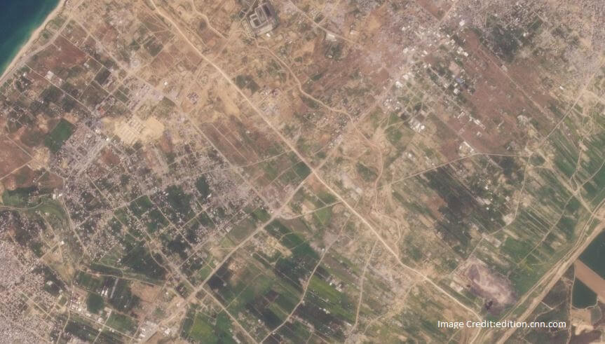
Satellite imagery shows that the Israeli military is building a road that splits Gaza in two and has now reached the Mediterranean coast, according to a CNN analysis. The road is part of a security plan aimed at controlling the territory for months and possibly years, say Israeli officials. The analysis reveals that the east-west road, which has been under construction for weeks, now stretches from the Gaza-Israeli border area across the entire roughly 6.5-kilometer-wide strip, dividing northern Gaza, including Gaza City, from the south of the enclave.
The road includes about 2 kilometers of existing road, while the rest is new. Israeli officials said that they are using the route to “establish (an) operational foothold in the area” and allow “the passage of forces as well as logistical equipment.” The IDF said the road existed before the war and was being “renovated” due to armored vehicles “damaging it.”
Israeli Prime Minister Benjamin Netanyahu unveiled a plan for a post-Hamas future for Gaza, including the “complete demilitarization” of the enclave and the overhaul of its security, civil administration, and education systems. Palestinians living in Gaza fear that Israel’s post-war security plans will further restrict their freedom of movement, remembering the days of Israeli occupation prior to 2005.
The “Netzarim Corridor,” named after the former Israeli settlement of Netzarim in Gaza, intersects one of Gaza’s two main north-south roads, Salaheddin Street, creating a strategic, central junction. The road, which will be used for at least a year, will have three lanes: one for heavy tanks and armored vehicles, another for lighter vehicles, and a third for faster movement. It will be possible to drive on the Netzarim Corridor from Be’eri, an Israeli kibbutz near the Gaza border, to the Mediterranean Sea in seven minutes.
Israeli Minister for Diaspora Affairs Amichai Chikli told CNN that the new road will “make it easier” for the Israeli military to launch raids north of Gaza City and south to the central area of the Gaza Strip. A series of satellite images shows how Israel is extending an existing road to build the corridor, including newly bulldozed sections of road to the east and the west of the existing one. It is to be noted that the Israeli military began bulldozing a path for its armored vehicles soon after declaring war against Hamas on October 7.